top of page


SERVICES
Aerial Imagery & Video in 2.7k, 4k, & 5.2k
Real Estate - Commercial
Real Estate
Real Estate - Residential
Real Estate - Residential
Photography
Photograpy
Construction
Construction & Industrial
There are a lot of applications for using drones on construction sites. One of the most popular uses is 3D modelling to evaluate the topography of a site, identify earthmoving needs, and to monitor progress of projects against project schedules. Other industries using drone-based 3D modeling include mining, inspection, golf courses, and land development.
Altius drone service is also able to live stream video to help cut travel costs when progress reports are needed and the location is remote or in another city.
3D Modeling
3D Modeling
3D models are a great way to visualize the 3 dimensionalities of your object of interest. Construction sites commonly use 3D models to evaluate the topography of a site, identify earthmoving needs, and to monitor progress of projects against project schedules. Other industries using drone-based 3D modeling include mining, inspection, golf courses, and land development.
When creating 3D modelling, capturing oblique imagery is paramount and improves the appearance and shape reconstruction of the model. When flying the perimeter, Altius drones take images every 5 meters, at between 60 and 50 degrees down, looking towards the centroid of the map area. The image capture is performed at the set flight altitude.
Agriculture
Agriculture
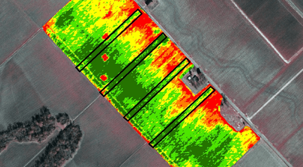
NDVI (Normalized Difference Vegetation Index) is a common measure in remote sensing for agriculture. NDVI cameras capture how near infrared light is reflected compared to visible red. It helps differentiate bare soil from grass or forest, detect plants under stress, and differentiate between crops and crop stages. NDVI can give you powerful insights making it easier to visualize crop health that you wouldn’t otherwise be able to see. It shows you where the problems are in advance, allowing you to take action sooner. Drone mapping software is becoming one of the most successful methods of easily and quickly assessing plant and crop health resulting in improved farm yields.
Using the DJI Inspire 1 with the NDVI camera, Altius Drone Service is able to help farmers improve their crop health by collecting data.
Contact Us today to learn more.
Inspection
Inspection
Altius uses portable industrial drones equipped with powerful, side-by-side visual and thermal cameras that provide commercial pilots a reliable tool to operate better, safer & quicker in challenging environments. We can measure temperatures and conveniently store images and temperature data for efficient reporting and analysis, adding immediate value to a range of industrial or time-sensitive operations today from utility inspections to emergency response.
We also perform visual inspections using a drone with a powerful zoom lens to get in close to those hard to see, high up areas like towers or roofs. This saves you time, and most importantly is a safe way to perform inspections.
Video Production / Promotional & Corporate Videos
Video Production
bottom of page


